
Africa
From jeena
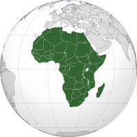 Africa Africa |
|
| Area | 30,221,532 km2 (11,668,599 sq mi) |
|---|---|
| Population | 1,032,532,974[1] (2011, 2nd) |
| Pop. density | 30.51/km2 (about 80/sq mi) |
| Demonym | African |
| Countries | 57 (list of countries) |
| Dependencies | |
| Languages | Languages of Africa |
| Time Zones | UTC-1 to UTC+4 |
| Largest cities | List of metropolitan areas in Africa List of cities in Africa |
Africa, particularly central Eastern Africa, is the origin of humans and the Hominidae clade (great apes), as evidenced by the discovery of the earliest hominids and their ancestors, as well as later ones that have been dated to around seven million years ago – including Sahelanthropus tchadensis, Australopithecus africanus, A. afarensis, Homo erectus, H. habilis and H. ergaster – with the earliest Homo sapiens (modern human) found in Ethiopia being dated to circa 200,000 years ago.[4] Africa straddles the equator and encompasses numerous climate areas; it is the only continent to stretch from the northern temperate to southern temperate zones.[5] The African expected economic growth rate is at about 5.0% for 2010 and 5.5% in 2011.[6]
Contents
|
Etymology
Afri was a Latin name used to refer to the Carthaginians who dwelt in North Africa in modern-day Tunisia. Their name is usually connected with Phoenician afar, "dust", but a 1981 hypothesis[7] has asserted that it stems from the Berber word ifri or ifran meaning "cave" and "caves", in reference to cave dwellers.[8] Africa or Ifri or Afer[8] is the name of Banu Ifran from Algeria and Tripolitania (Berber Tribe of Yafran).[9]Under Roman rule, Carthage became the capital of Africa Province, which also included the coastal part of modern Libya.[10] The Latin suffix "-ica" can sometimes be used to denote a land (e.g., in Celtica from Celtes, as used by Julius Caesar). The later Muslim kingdom of Ifriqiya, modern-day Tunisia, also preserved a form of the name.
Other etymological hypotheses that have been postulated for the ancient name "Africa":
- the 1st century Jewish historian Flavius Josephus (Ant. 1.15) asserted that it was named for Epher, grandson of Abraham according to Gen. 25:4, whose descendants, he claimed, had invaded Libya.
- Latin word aprica ("sunny") mentioned by Isidore of Seville in Etymologiae XIV.5.2.
- the Greek word aphrike (Αφρική), meaning "without cold." This was proposed by historian Leo Africanus (1488–1554), who suggested the Greek word phrike (φρίκη, meaning "cold and horror"), combined with the privative prefix "a-", thus indicating a land free of cold and horror.[11]
- Another theory is that the word aphrikè comes from aphròs, foam and Aphrikè, land of foam, meaning the land of the big waves (like Attica, from the word aktè, Aktikè meaning land of the coasts).[citation needed]
- Massey, in 1881, derived an etymology from the Egyptian af-rui-ka, "to turn toward the opening of the Ka." The Ka is the energetic double of every person and "opening of the Ka" refers to a womb or birthplace. Africa would be, for the Egyptians, "the birthplace."[12]
- yet another hypothesis was proposed by Michèle Fruyt in Revue de Philologie 50, 1976: 221–238, linking the Latin word with africus 'south wind', which would be of Umbrian origin and mean originally 'rainy wind'.
History
Main article: History of Africa
Further information: History of North Africa, History of West Africa, History of Central Africa, History of East Africa, and History of Southern Africa
Prehistory
Main article: Recent African origin of modern humans

Throughout humanity's prehistory, Africa (like all other continents) had no nation states, and was instead inhabited by groups of hunter-gatherers such as the Khoi and San.[17][18][19]
At the end of the Ice Ages, estimated to have been around 10,500 BC, the Sahara had again become a green fertile valley, and its African populations returned from the interior and coastal highlands in Sub-Saharan Africa[citation needed]. However, the warming and drying climate meant that by 5000 BC the Sahara region was becoming increasingly dry and hostile. The population trekked out of the Sahara region towards the Nile Valley below the Second Cataract where they made permanent or semi-permanent settlements. A major climatic recession occurred, lessening the heavy and persistent rains in Central and Eastern Africa. Since this time dry conditions have prevailed in Eastern Africa, and increasingly during the last 200 years, in Ethiopia.
The domestication of cattle in Africa preceded agriculture and seems to have existed alongside hunter-gathering cultures. It is speculated that by 6000 BC cattle were already domesticated in North Africa.[20] In the Sahara-Nile complex, people domesticated many animals including the donkey, and a small screw-horned goat which was common from Algeria to Nubia. In the year 4000 BC the climate of the Sahara started to become drier at an exceedingly fast pace.[21] This climate change caused lakes and rivers to shrink significantly and caused increasing desertification. This, in turn, decreased the amount of land conducive to settlements and helped to cause migrations of farming communities to the more tropical climate of West Africa.[21]
By the first millennium BC ironworking had been introduced in Northern Africa and quickly spread across the Sahara into the northern parts of sub-Saharan Africa,[22] and by 500 BC metalworking began to become commonplace in West Africa. Ironworking was fully established by roughly 500 BC in many areas of East and West Africa, although other regions didn't begin ironworking until the early centuries AD. Copper objects from Egypt, North Africa, Nubia and Ethiopia dating from around 500 BC have been excavated in West Africa, suggesting that trans-saharan trade networks had been established by this date.[21]
Early civilizations
Main article: Ancient African history


An independent centre of civilisation with trading links to Phoenicia was established by Phoenicians from Tyre on the north-west African coast at Carthage.[27][28][29]
European exploration of Africa began with Ancient Greeks and Romans. In 332 BC, Alexander the Great was welcomed as a liberator in Persian-occupied Egypt. He founded Alexandria in Egypt, which would become the prosperous capital of the Ptolemaic dynasty after his death.[30] Following the conquest of North Africa's Mediterranean coastline by the Roman Empire, the area was integrated economically and culturally into the Roman system. Roman settlement occurred in modern Tunisia and elsewhere along the coast. Christianity spread across these areas at an early date, from Judaea via Egypt and beyond the borders of the Roman world into Nubia;[citation needed] by AD 340 at the latest, it had become the state religion of the Aksumite Empire thanks to Syro-Greek missionaries who arrived by way of the Red Sea.[31]
In the early 7th century, the newly formed Arabian Islamic Caliphate expanded into Egypt, and then into North Africa. In a short while the local Berber elite had been integrated into Muslim Arab tribes. When the Umayyad capital Damascus fell in the 8th century, the Islamic center of the Mediterranean shifted from Syria to Qayrawan in North Africa. Islamic North Africa had become diverse, and a hub for mystics, scholars, jurists and philosophers. During the above mentioned period, Islam spread to sub-Saharan Africa, mainly through trade routes and migration.[32]
9th–18th centuries
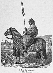

By the 9th century a string of dynastic states, including the earliest Hausa states, stretched across the sub-saharan savannah from the western regions to central Sudan. The most powerful of these states were Ghana, Gao, and the Kanem-Bornu Empire. Ghana declined in the 11th century but was succeeded by the Mali Empire which consolidated much of western Sudan in the 13th century. Kanem accepted Islam in the 11th century.
In the forested regions of the West African coast, independent kingdoms grew up with little influence from the Muslim north. The Kingdom of Nri of the Igbo was established around the 9th century and was one of the first. It is also one of the oldest Kingdom in modern day Nigeria and was ruled by the Eze Nri. The Nri kingdom is famous for its elaborate bronzes, found at the town of Igbo Ukwu. The bronzes have been dated from as far back as the 9th century.[35]
The Almoravids were a Berber dynasty from the Sahara that spread over a wide area of northwestern Africa and the Iberian peninsula during the 11th century.[36] The Banu Hilal and Banu Ma'qil were a collection of Arab Bedouin tribes from the Arabian peninsula who migrated westwards via Egypt between the 11th and 13th centuries. Their migration resulted in the fusion of the Arabs and Berbers, where the locals were Arabized,[37] and Arab culture absorbed elements of the local culture, under the unifying framework of Islam.[38]

Height of slave trade
See also: Arab slave trade and Atlantic slave trade

In West Africa, the decline of the Atlantic slave trade in the 1820s caused dramatic economic shifts in local polities. The gradual decline of slave-trading, prompted by a lack of demand for slaves in the New World, increasing anti-slavery legislation in Europe and America, and the British Royal Navy's increasing presence off the West African coast, obliged African states to adopt new economies. Between 1808 and 1860, the British West Africa Squadron seized approximately 1,600 slave ships and freed 150,000 Africans who were aboard.[45]
Action was also taken against African leaders who refused to agree to British treaties to outlaw the trade, for example against "the usurping King of Lagos", deposed in 1851. Anti-slavery treaties were signed with over 50 African rulers.[46] The largest powers of West Africa (the Asante Confederacy, the Kingdom of Dahomey, and the Oyo Empire) adopted different ways of adapting to the shift. Asante and Dahomey concentrated on the development of "legitimate commerce" in the form of palm oil, cocoa, timber and gold, forming the bedrock of West Africa's modern export trade. The Oyo Empire, unable to adapt, collapsed into civil wars.[47]
Colonialism and the "Scramble for Africa"
Main article: Colonization of Africa
Further information: Scramble for Africa


Belgium
Germany
Spain
France
United Kingdom
Italy
Portugal
independent
Berlin Conference
The Berlin Conference held in 1884–85 was an important event in the political future of African ethnic groups. It was convened by King Leopold II of Belgium, and attended by the European powers that laid claim to African territories. It sought to bring an end to the Scramble for Africa by European powers by agreeing on political division and spheres of influence. They set up the political divisions of the continent, by spheres of interest, that exist in Africa today.Independence struggles
Imperial rule by Europeans would continue until after the conclusion of World War II, when almost all remaining colonial territories gradually obtained formal independence. Independence movements in Africa gained momentum following World War II, which left the major European powers weakened. In 1951, Libya, a former Italian colony, gained independence. In 1956, Tunisia and Morocco won their independence from France.[48] Ghana followed suit the next year (March 1957),[49] becoming the first of the sub-Saharan colonies to be freed. Most of the rest of the continent became independent over the next decade.Portugal's overseas presence in Sub-Saharan Africa (most notably in Angola, Cape Verde, Mozambique, Guinea-Bissau and São Tomé and Príncipe) lasted from the 16th century to 1975, after the Estado Novo regime was overthrown in a military coup in Lisbon. Rhodesia unilaterally declared independence from the United Kingdom in 1965, under the white minority government of Ian Smith, but was not internationally recognised as an independent state (as Zimbabwe) until 1980, when black nationalists gained power after a bitter guerrilla war. Although South Africa was one of the first African countries to gain independence, the state remained under the control of the country's white minority through a system of racial segregation known as apartheid until 1994.
Post-colonial Africa
Today, Africa contains 54 sovereign countries, most of which have borders that were drawn during the era of European colonialism. Since colonialism, African states have frequently been hampered by instability, corruption, violence, and authoritarianism. The vast majority of African states are republics that operate under some form of the presidential system of rule. However, few of them have been able to sustain democratic governments on a permanent basis, and many have instead cycled through a series of coups, producing military dictatorships.
Cold War conflicts between the United States and the Soviet Union, as well as the policies of the International Monetary Fund, also played a role in instability. When a country became independent for the first time, it was often expected to align with one of the two superpowers. Many countries in Northern Africa received Soviet military aid, while many in Central and Southern Africa were supported by the United States, France or both. The 1970s saw an escalation, as newly independent Angola and Mozambique aligned themselves with the Soviet Union, and the West and South Africa sought to contain Soviet influence by funding insurgency movements. There was a major famine in Ethiopia, when hundreds of thousands of people starved. Some claimed that Marxist/Soviet policies made the situation worse.[50][51][52] The most devastating military conflict in modern independent Africa has been the Second Congo War. By 2008, this conflict and its aftermath had killed 5.4 million people. Since 2003 there has been an ongoing conflict in Darfur which has become a humanitarian disaster. Another notable tragic event is the 1994 Rwandan Genocide in which an estimated 800 000 people were murdered. AIDS has also been a prevalent issue in post-colonial Africa.
In the 21st century, however, the number of armed conflicts in Africa has steadily declined. For instance, the civil war in Angola came to an end in 2002 after nearly 30 years. This has coincided with many countries abandoning communist style command economies and opening up for market reforms. The improved stability and economic reforms have led to a great increase in foreign investment into many African nations, mainly from China, which has spurred quick economic growth in many countries, seemingly ending decades of stagnation and decline. Several African economies are among the world's fasted growing as of 2011. A significant part of this growth can also be attributed to the facilitated diffusion of information technologies and specifically mobile telephony [53].
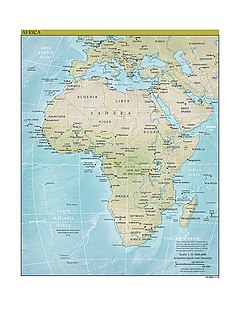
Geography

Main article: Geography of Africa
Africa is the largest of the three great southward projections from
the largest landmass of the Earth. Separated from Europe by the Mediterranean Sea, it is joined to Asia at its northeast extremity by the Isthmus of Suez (transected by the Suez Canal), 163 km (101 mi) wide.[54] (Geopolitically, Egypt's Sinai Peninsula east of the Suez Canal is often considered part of Africa, as well.)[55]
Africa's largest country is Algeria, and its smallest country is the Seychelles, an archipelago off the east coast.[58] The smallest nation on the continental mainland is The Gambia.
According to the ancient Romans, Africa lay to the west of Egypt, while "Asia" was used to refer to Anatolia and lands to the east. A definite line was drawn between the two continents by the geographer Ptolemy (85–165 AD), indicating Alexandria along the Prime Meridian and making the isthmus of Suez and the Red Sea the boundary between Asia and Africa. As Europeans came to understand the real extent of the continent, the idea of Africa expanded with their knowledge.
Geologically, Africa includes the Arabian Peninsula; the Zagros Mountains of Iran and the Anatolian Plateau of Turkey mark where the African Plate collided with Eurasia. The Afrotropic ecozone and the Saharo-Arabian desert to its north unite the region biogeographically, and the Afro-Asiatic language family unites the north linguistically.
Climate
Main article: Climate of Africa

Fauna

Main article: Fauna of Africa
Africa boasts perhaps the world's largest combination of density and "range of freedom" of wild animal populations and diversity, with wild populations of large carnivores (such as lions, hyenas, and cheetahs) and herbivores (such as buffalo, elephants, camels, and giraffes) ranging freely on primarily open non-private plains. It is also home to a variety of "jungle" animals including snakes and primates and aquatic life such as crocodiles and amphibians. In addition, Africa has the largest number of megafauna species, as it was least affected by the extinction of the Pleistocene megafauna.Ecology

Biodiversity
Africa has over 3,000 protected areas, with 198 marine protected areas, 50 biosphere reserves and 80 wetlands reserves. Significant habitat destruction, increases in human population and poaching are reducing Africa's biological diversity. Human encroachment, civil unrest and the introduction of non-native species threatens biodiversity in Africa. This has been exacerbated by administrative problems, inadequate personnel and funding problems.[59]Politics
See also: List of political parties in Africa by country
There are clear signs of increased networking among African organisations and states. For example, in the civil war in the Democratic Republic of the Congo (former Zaire), rather than rich, non-African countries intervening, neighbouring African countries became involved (see also Second Congo War). Since the conflict began in 1998, the estimated death toll has reached 5 million.The African Union
Main article: African Union
The African Union (AU) is a 54 member federation consisting of all of Africa's states except Morocco. The union was formed, with Addis Ababa, Ethiopia, as its headquarters, on 26 June 2001. The union was officially established on 9 July 2002[65] as a successor to the Organisation of African Unity (OAU). In July 2004, the African Union's Pan-African Parliament (PAP) was relocated to Midrand, in South Africa, but the African Commission on Human and Peoples' Rights
remained in Addis Ababa. There is a policy in effect to decentralize
the African Federation's institutions so that they are shared by all the
states.The African Union, not to be confused with the AU Commission, is formed by the Constitutive Act of the African Union, which aims to transform the African Economic Community, a federated commonwealth, into a state under established international conventions. The African Union has a parliamentary government, known as the African Union Government, consisting of legislative, judicial and executive organs. It is led by the African Union President and Head of State, who is also the President of the Pan African Parliament. A person becomes AU President by being elected to the PAP, and subsequently gaining majority support in the PAP. The powers and authority of the President of the African Parliament derive from the Constitutive Act and the Protocol of the Pan African Parliament, as well as the inheritance of presidential authority stipulated by African treaties and by international treaties, including those subordinating the Secretary General of the OAU Secretariat (AU Commission) to the PAP. The government of the AU consists of all-union (federal), regional, state, and municipal authorities, as well as hundreds of institutions, that together manage the day-to-day affairs of the institution.
Political associations such as the African Union offer hope for greater co-operation and peace between the continent's many countries. Extensive human rights abuses still occur in several parts of Africa, often under the oversight of the state. Most of such violations occur for political reasons, often as a side effect of civil war. Countries where major human rights violations have been reported in recent times include the Democratic Republic of the Congo, Sierra Leone, Liberia, Sudan, Zimbabwe, and Côte d'Ivoire.
|
|

Economy


Main article: Economy of Africa
See also: Economy of the African Union
Although it has abundant natural resources, Africa remains the world's poorest and most underdeveloped continent, the result of a variety of causes that may include the spread of deadly diseases (notably HIV/AIDS and malaria), corrupt governments that have often committed serious human rights violations, failed central planning, high levels of illiteracy, lack of access to foreign capital, and frequent tribal and military conflict (ranging from guerrilla warfare to genocide).[66] According to the United Nations' Human Development Report in 2003, the bottom 25 ranked nations (151st to 175th) were all African.[67]Poverty, illiteracy, malnutrition and inadequate water supply and sanitation, as well as poor health, affect a large proportion of the people who reside in the African continent. In August 2008, the World Bank[68] announced revised global poverty estimates based on a new international poverty line of $1.25 per day (versus the previous measure of $1.00). 80.5% of the Sub-Saharan Africa population was living on less than $2.50 (PPP) a day in 2005, compared with 85.7% for India.[69]
The new figures confirm that sub-Saharan Africa has been the least successful region of the world in reducing poverty ($1.25 per day); some 50% of the population living in poverty in 1981 (200 million people), a figure that rose to 58% in 1996 before dropping to 50% in 2005 (380 million people). The average poor person in sub-Saharan Africa is estimated to live on only 70 cents per day, and was poorer in 2003 than he or she was in 1973 [70] indicating increasing poverty in some areas. Some of it is attributed to unsuccessful economic liberalization programs spearheaded by foreign companies and governments, but other studies and reports have cited bad domestic government policies more than external factors.[71][72][73]
From 1995 to 2005, Africa's rate of economic growth increased, averaging 5% in 2005. Some countries experienced still higher growth rates, notably Angola, Sudan and Equatorial Guinea, all three of which had recently begun extracting their petroleum reserves or had expanded their oil extraction capacity. The continent is believed to hold 90% of the world’s cobalt, 90% of its platinum, 50% of its gold, 98% of its chromium, 70% of its tantalite,[74] 64% of its manganese and one-third of its uranium.[75] The Democratic Republic of the Congo (DRC) has 70% of the world’s coltan, and most mobile phones in the world are made with elements refined from this mineral. The DRC also has more than 30% of the world’s diamond reserves.[76] Guinea is the world’s largest exporter of bauxite.[77] As the growth in Africa has been driven mainly by services and not manufacturing or agriculture, it has been growth without jobs and without reduction in poverty levels. In fact, the food security crisis of 2008 which took place on the heels of the global financial crisis has pushed back 100 million people into food insecurity.[78]
In recent years, the People's Republic of China has built increasingly stronger ties with African nations. In 2007, Chinese companies invested a total of US$1 billion in Africa.[79]
A Harvard University study showed that Africa could easily feed itself, if only it had decent governance.[80]
No comments:
Post a Comment